1. Summary: Winter storm “Elli” and severe frost warning
An unusually deep winter low named “Elli” is moving from the Bay of Biscay toward Germany and will create a sharp boundary between mild Atlantic air and incoming arctic cold. This set-up produces a broad band of heavy snowfall, snowstorm conditions, freezing rain, icy roads and storm to near-hurricane gusts across a wide west–east corridor. Berlin lies on the cold, northern side of that corridor and can expect snow, strong east to northeast winds and a following phase of severe frost that lasts several days.
What is “Elli” and why is it important?
“Elli” is a marked winter storm that deepens over the North Sea and brings a narrow but intense zone where warm and very cold air meet. Meteorologists call it a brisant weather situation because the contrast allows heavy snow, drifting snow, glaze ice and strong gusts to occur together. While some media use dramatic labels like “blizzard” or “snow chaos,” national weather experts describe the event as a strong but not unprecedented winter storm for this time of year.
2. Forecast for Berlin and Northeast Germany
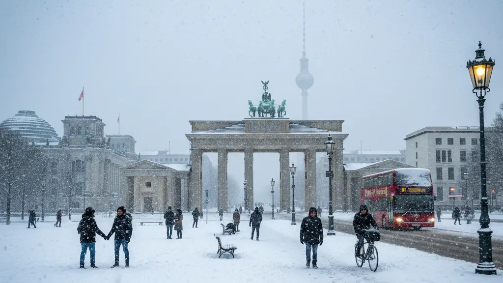
Forecast charts show Berlin at the northern edge of the heaviest snowfall band. Exact snow totals depend on the storm track: models suggest anything from a few centimeters to about 10–15 cm in parts of the region. The southwest of Berlin and the Potsdam area are likelier to see the higher totals, while the northeast of the city may receive less. Snow will arrive later in the morning for many people, which can make the rush hour particularly tricky.
Snow amounts and timing
Snowfall timing and accumulation vary with the storm path. Current model ensembles place the main snow band crossing Germany from west to east and reaching areas north of central Germany. For Berlin the most likely scenarios are a late-morning to afternoon onset of snow, then several hours of moderate to heavy snowfall in places.
- Possible accumulations near Berlin: a few centimeters to around 10–15 cm in the southwest and Potsdam area.
- Spatial variation: heavier totals from Dresden across Magdeburg toward Bremen; Berlin on the northern fringe.
- Timing: snow in Berlin is expected to begin later in the morning, possibly after 9:00, increasing toward midday.
Wind, drifting snow and blizzard potential
On the cold north side of “Elli” an east to northeast wind will strengthen, reaching gusty and sometimes stormy strengths inland and stronger along the coast. That wind will blow falling and existing snow into drifts and may reduce visibility locally. While some outlets warn of “blizzard-like” conditions, experts emphasize that the most intense part of the storm is spatially limited; nevertheless, significant snowdrift and temporary white-out conditions are possible where wind and snow combine.
Temperatures and severe frost
A key hazard is the cold air that follows the storm. Arctic air arriving from the north and east will push temperatures far below freezing. Nighttime lows in eastern Germany, including the Berlin region, may reach around -15°C in sheltered “cold bowl” locations; daytime highs will often stay well below zero, roughly between -10°C and -1°C. After an initial period with wind and possibly freezing rain, temperatures are forecast to fall into the deep frost range, favoring widespread icing of roads and sidewalks.
3. Main hazards and likely impacts
The combined effects of snowfall, strong winds and a subsequent plunge in temperatures create multiple hazards: heavy snow and snowdrifts that block routes, glaze ice (glatteis) and invisible black ice after short thawing and rapid refreezing, interruptions to public transport and flights, and lasting challenges for road and rail operations while persistent frost keeps surfaces slippery for days.
Transport and infrastructure
- Road traffic: Risk of stranded cars, slow-moving convoys, and collisions due to snow, drifting snow and black ice.
- Public transport: Delays and cancellations likely in regional rail, S-Bahn, buses and trams; expect longer commute times.
- Air travel: Flights may be delayed or canceled where snow and ice affect runways and ground operations.
- Critical services: Snow and ice can disrupt deliveries, waste collection and emergency vehicle access in heavily affected neighborhoods.
Daily life, health and safety
- Slips and falls: Persistent glatteis increases the risk for pedestrians, especially in the mornings and evenings.
- Cold exposure: Several nights with severe frost mean a higher risk for vulnerable people and outdoor workers.
- Power and heating: Heavy snow and gusts can stress infrastructure; household heating needs will be elevated during the cold spell.
4. Practical advice and safety steps
Prepare now for both the storm and the cold days that follow. The main goals are to reduce travel during peak impact times, protect vulnerable people and property, and be ready for icy conditions after a short thaw and rapid refreeze.
- Check forecast updates from the national weather service and local authorities before travel.
- Consider delaying non-essential travel during peak snowfall and strong gusts; if you must travel, allow extra time.
- Fit your vehicle with winter tires and carry an emergency kit (blankets, charged phone, flashlight, food, water, shovel).
- For pedestrians: wear sturdy shoes with good grip, use handrails and take extra care on stairs and corners.
- Look after others: check on elderly neighbors and anyone who may struggle with the cold.
- If you encounter freezing rain or compacted snow, braking distances increase—drive slowly and smoothly.
- Keep paths and immediate entrances clear of snow where safe to do so, and use sand or grit to reduce ice risk.
- Avoid leaving pets long outdoors during the severe frost period.
5. Short timeline: what to expect
- Night to Friday morning: Snow begins across southwestern parts of the country, extending in a broad arc to a Hamburg–Dresden line; Berlin may still be dry early on.
- Friday late morning to afternoon: Snow arrives at the northern edge of the main band—Berlin likely sees increasing snow and gusty east–northeast winds, with visibility reductions and drifting snow.
- Friday evening to Saturday: Precipitation tapers in many places, but winds can continue to cause snowdrift; temperatures begin to fall steadily behind the front.
- Saturday into the following days: Arctic cold establishes itself. Nights can reach around -15°C in cold pockets; daytime highs remain well below freezing. Clear, sunny periods are possible but glatteis remains a hazard.
- Sunday: Often described as visually pleasant with clearer air and sunshine, but high risk of persistent ice on roads and sidewalks once temperatures drop again after sunset.
6. Aftermath and climate context
While this event is significant, meteorologists place it in the context of natural climate variability. Experts note that pronounced contrasts between warm and cold air masses can still produce strong winter events even in a warming world. Long-term model trends do not show a clear signal for an exceptionally long cold period into early February; instead, forecasts suggest conditions near the climatological averages for recent decades. Nonetheless, a cold snap after heavy snow raises practical hazards for several days.
What comes next
Expect a transition from stormy snow to clear but very cold conditions. The most dangerous period for travel and pedestrian accidents may be after the storm when fallen snow combines with freezing temperatures to form invisible ice layers. Continued updates from weather services and local authorities will give the best guidance on evolving warnings and travel advisories.
7. Sources and further information
This briefing is based on the latest meteorological forecasts and reporting from national and regional weather services and news outlets. For real-time warnings, consult official weather warnings and local authorities in Berlin and northeast Germany. Stay tuned to updates because small changes in the storm track can alter local impacts and snow totals.
