1. Immediate overview: dangerous winter event approaching
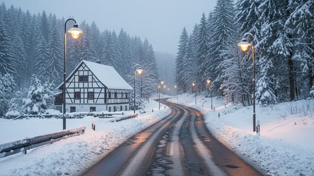
Germany faces an extreme winter weather event between Thursday and Saturday, 8–10 January 2026. Forecasts indicate heavy snowfall, freezing rain (sleet), strong winds, and severe snowdrifts that will create life‑threatening conditions on roads and in exposed areas. Authorities and weather experts warn that travel will be extremely hazardous and that people should change plans and stay home where possible.
Key hazards include sudden glazes of black ice from freezing rain, rapid snowfall rates that can deposit 5–15 cm within six hours in some areas, and blizzard‑like conditions with drifts and near‑zero visibility in the north. Experts describe the situation as an extreme event driven by a deepening storm system nicknamed ‘Elli’ and associated bombogenesis.
2. Weather details and main hazards
This storm combines very cold air with a powerful cyclonic development. The main threats are:
- Freezing rain and black ice: In the south and in transition zones, rain that freezes on contact will create ice coatings on roads and pavements, turning streets into ice sheets.
- Heavy snow and blizzards: Northern and northeastern regions may see blizzard conditions with drifting snow and locally very high snowfall totals—storms may drop up to 50 cm in isolated spots, with persistent snowfall of 20–40 cm in some upland areas.
- Strong winds and storm surge: Gale to hurricane‑force gusts, especially along the North Sea coast and over mountain ridges, will form heavy snowdrifts, reduce visibility to meters, and create danger from flying debris and storm surges in coastal towns.
- Rapid temperature drops: Temperatures could fall sharply, with pockets of extreme cold near minus 20 °C in some regions, increasing the risk of hypothermia for anyone stranded outdoors.
Regional highlights
Some regions will be hit harder than others:
- North and northeast (including coastal areas): Blizzard‑like conditions, severe snowdrifts, near‑zero visibility, and the highest risk of very heavy local snowfall.
- Central highlands and mountain ranges: Persistent heavy snow with large accumulations and increased avalanche risk in exposed terrain.
- South and transition zones: Freezing rain creating widespread black ice on roads and sidewalks.
- Specific regions named in current warnings (for situational awareness): East Frisia, parts of North Rhine‑Westphalia, the eastern half of the country; a dangerous air‑mass boundary is expected between Hamburg and Berlin.
Wind gusts could reach storm force, and in places like the North Sea coast and the Harz, gusts approaching wind strength 12 are possible. Coastal towns such as Flensburg should prepare for storm surge risk and local flood impacts.
3. Impact on transportation and services
The combination of ice, heavy snow, and strong winds will disrupt all forms of travel and some critical services:
- Roads: Life‑threatening driving conditions—black ice, packed snow, and drifts will cause accidents and long delays. Even well‑equipped vehicles can become immobile in blizzard conditions.
- Rail: Major disruptions and cancellations are likely in affected northern corridors. Expect speed restrictions on high‑speed lines and limited service; some operators are already applying flexible ticket rules for affected days.
- Air travel: At the time of the alert, flights may still operate, but poor visibility, heavy snow and wind could lead to delays and cancellations at short notice.
- Local services: Snow clearance may be limited in places due to shortages of grit and salt, strike action affecting staff, or regulatory changes in some cities. This can prolong hazardous road and pavement conditions.
Authorities emphasize that incidents quickly cascade: a single crash or stranded vehicle can block a road, create long queues, and leave many people exposed to cold or danger while rescue resources are busy elsewhere.
4. Clear, practical safety advice for drivers and pedestrians
The clearest advice from meteorologists and road safety experts is simple: avoid travel during the worst periods. If you must travel, prepare thoroughly and drive only if you are confident and equipped for extreme winter conditions.
- Reduce speed and increase following distance—stopping distances on ice are far longer.
- Avoid sudden steering, braking, or acceleration; use gentle inputs.
- Do not rely solely on driver‑assist systems—on black ice and deep snow these systems may not work as intended.
- If visibility collapses in a whiteout, exit the road safely if possible and wait in a sheltered place; do not stop in a traffic lane.
Pre‑trip checklist
- Check tires: Use certified winter tires and ensure tread depth is legal and sufficient for snow and ice. Incorrect or summer tires greatly increase crash risk and can affect insurance coverage.
- Lights and visibility: Clear all windows, mirrors and lights of snow and ice before departure; carry de‑icer and a scraper.
- Fuel and battery: Keep the fuel tank at least half full and make sure the battery is healthy—cold reduces battery capacity.
- Emergency kit: Pack warm clothing, blankets, a charged mobile phone and power bank, a flashlight, food and water, a first‑aid kit, and basic tools including a shovel and traction aids (sand or cat litter).
- Inform someone: Tell a friend or family member your route and expected arrival time.
Driving tips in ice and snow:
5. If you become stranded: immediate steps
Being prepared can save lives. If you are stranded in a vehicle during severe cold or a blizzard, follow these steps to stay as safe as possible.
- Stay with the vehicle unless there is immediate danger—your car is easier for rescuers to find than a person on foot in a storm.
- Call emergency services if anyone is injured or if you are in danger; give clear location information and describe conditions.
- Make the car visible: Use hazard lights, reflectors or a bright cloth on the antenna. Run the engine for short periods to warm up, but ensure the exhaust pipe is not blocked by snow before doing so.
- Conserve fuel and stay warm: Insulate with blankets and avoid unnecessary movement. Keep a window slightly open to prevent carbon monoxide buildup if the engine is running.
- Ration food and water and check phones sparingly to conserve battery; use a power bank if available.
If you must walk for help, leave a note in the car with your intended direction and time of departure, and dress for extreme cold. Only attempt to walk if you are certain of the distance and route and visibility allows it.
6. What communities, employers and authorities should do
Local governments, businesses and infrastructure managers should activate contingency plans now. Key actions include prioritizing critical routes for snow clearance, advising remote work where possible, and coordinating emergency services for likely rescue demands.
Logistical and policy points
- Salt and grit management: Municipalities should prioritize main arteries and emergency routes, while being transparent about available resources—some areas report tighter supplies due to staffing issues and regulatory changes.
- Public transport: Rail and bus operators should communicate service changes early and allow flexible ticketing to reduce pressure on travelers.
- Coastal defenses: Prepare for storm surge and possible coastal flooding in vulnerable towns; clear emergency shelters and warn residents in low‑lying areas.
Employers are advised to permit remote work, stagger shifts, or delay operations during the worst of the event. Schools and non‑essential services should consider closures to reduce commuter risk.
7. Final recommendations and staying informed
Summary recommendations: plan ahead, avoid travel during the peak of the storm, fit winter tires, prepare an emergency kit, and follow official warnings. The situation may evolve quickly; forecasts suggest some milder air may return by Sunday in parts of the country, but localized heavy snow and icy conditions will remain a threat in higher terrain.
Follow updates from official meteorological services, local authorities and transport operators. Treat all travel advisories seriously—experts are warning of genuine life danger on roads during the most intense hours of this event. If you can, stay home and stay safe.
